
Where was that photo taken? If your images carry GPS data, the Google Maps plugin for WoodWing Assets answers that at a glance. It shows your selected files on a map, and it lets you add or fix locations without typing a single coordinate.
What it does for you
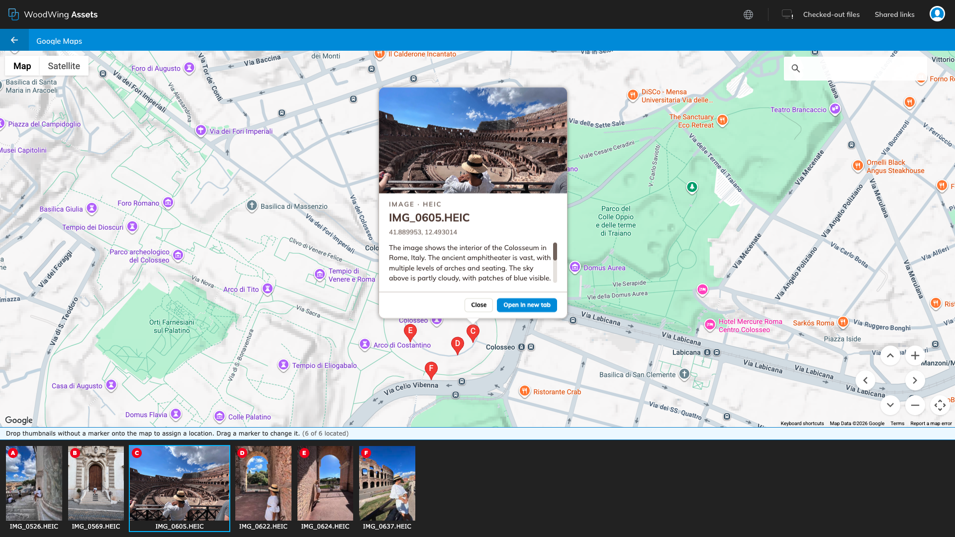
Select one or more images or videos and open the Google Maps plugin. Assets opens a map with a strip of thumbnails underneath. From there you can:
- See where files were taken. Every file with GPS data gets a lettered marker (A, B, C and so on), and the map zooms to fit them all.
- Add a location. Files without GPS data show up as plain thumbnails. Drag one onto the map and drop it where it belongs. The coordinates are saved to the file in Assets.
- Correct a location. Drag any marker to a new spot and the new position is saved.
- Find a place. Type an address or place name in the search box at the top right and the map jumps there.
Opening the map
- Select the images or videos you want to place. You can select a single file or a whole set.
- Right-click the selection and look for Google Maps under Plugins.
- Wait a moment while the map and thumbnails load.
Reading the map
The matching letter on a marker and on a thumbnail tells you which file is which. In the screenshot above, thumbnail C is the Colosseum interior shot, and marker C sits at its location.
Click a marker, or click its thumbnail, and an info window opens with:
- a preview of the file
- the file name and type
- the latitude and longitude
- the description, if the file has one
Use Close to dismiss the window, or Open in new tab to open the file in Assets. Use the Map and Satellite buttons in the top left to switch the view. Satellite is handy when you need to place a photo precisely, such as a particular building or a spot on a trail.
The line under the map keeps count for you. In the example it reads “6 of 6 located”, which means every selected file already has a location. If it said “4 of 6 located”, two thumbnails would still be waiting for you to drop them on the map.
Adding locations to files that have none
This is where the plugin saves the most time.
- Select a batch of photos from the same trip or shoot.
- Open the map. The files without GPS data appear as thumbnails without a marker.
- Find the place using the search box or by zooming and panning.
- Drag a thumbnail from the strip and drop it on the map.
A marker appears and the coordinates are written back to the file. Zoom in before you drop if the exact spot matters. If you land a little off, just drag the marker again.
You need permission to edit the files for the location to be saved. If you only have view access, you can still browse the map.
The GPS metadata group
The plugin reads and writes the location in the GPS metadata group. Many cameras and phones fill these fields in automatically when a photo is taken, and the plugin fills them in for you when you drop or move a marker.
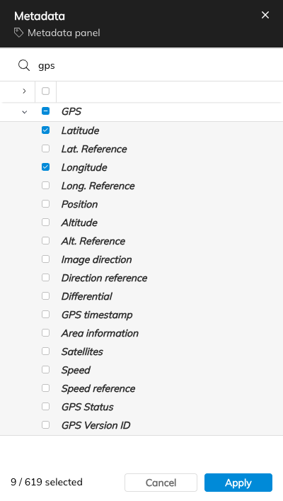
To see these fields in the Metadata panel, open the panel’s field selection, type “gps” in the search box, tick the fields you want and click Apply. The filter panel and the card each have their own field selection, so repeat the same steps there to show the GPS fields in those places too.
The GPS group holds many fields, but only a few matter here:
- Latitude and Longitude are the two that count. They decide where the marker appears. If a file has both, it is shown on the map. If either is missing, it appears as a thumbnail waiting to be placed.
- Lat. Reference and Long. Reference record whether the position is north or south, and east or west. Assets stores latitude and longitude as positive numbers with these references, and the plugin keeps them correct when it saves a location, so you normally do not edit them yourself.
The other fields in the group, such as Altitude, Image direction, Speed or GPS timestamp, are not used by the plugin. They are fine to leave as they are, and you do not need to show them in the panel.
Tips
- Find files that already have a location. A quick way to find assets with a GPS location is to type
gpsLatitude:* AND gpsLongitude:*into the search bar. Select the results and open the map to see them all at once. - Bookmark that search. Save the search above as a bookmark so you can run it again with one click. See the article on bookmarks and saved searches for how.
- Search by metadata afterwards. Once your files have coordinates, they carry real location data that stays with the file, so other people and tools can use it too.
Can’t see the plugin?
The plugin is installed on the trial server, so it should be there when you right-click an image or video. If you do not see Google Maps under Plugins, or the map does not load, contact us and we will check your account and the server settings.
Where to go next
If you want to review or change other details of your files, see the article on editing metadata.
